
Construction Progress Monitoring Drone Services
Keep your projects on schedule with consistent, high‑quality visual documentation from the sky. Aerial Ops Drone Services provides construction progress monitoring for commercial general contractors and infrastructure builders in Springfield, MO and across Southwest Missouri, Northern Arkansas, Central and Eastern Oklahoma and Kansas. We deliver detailed aerial photos, videos, maps, 3D models, and reports that help you track progress, improve communication, and reduce disputes.
Why Construction Progress Monitoring with Drones?
Accurate progress tracking is critical on every job. Our construction progress monitoring drone services give you:
-
Consistent visual records of your site from the same angles week after week
-
Clear communication with owners, investors, and stakeholders who can’t always visit the site
-
Improved safety, reducing the need for personnel to access hazardous or hard‑to‑reach areas
-
Reduced disputes and change orders, backed by time‑stamped imagery and as‑built documentation
-
Better decision‑making, with current site information instead of outdated plans or photos
Whether you’re building commercial structures, roads, bridges, or utilities along rights‑of‑way, our aerial construction monitoring gives you the documentation you need to manage risk and keep projects moving.
Aerial Progress Photography
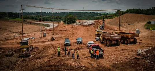
We capture high‑resolution aerial photos on a regular schedule to document every stage of your project. Images are taken from consistent, repeatable vantage points so you can easily compare progress over time. Use these photos for internal reporting, owner updates, RFIs, and closeout documentation.

Drone Progress Video & Site Walkthroughs
Our drone video provides visual “site walks” from above, giving project managers, owners, and remote stakeholders a clear understanding of what’s happening on site. Video updates are perfect for progress meetings, schedule reviews, and marketing communications once the project advances.

2D Orthomosaic Maps & 3D Site Models
We generate georeferenced 2D orthomosaic maps and 3D models of your construction site to support planning, coordination, and verification:
-
Visualize the entire site in one accurate, up‑to‑date view
-
Measure distances, areas, and relative positions
-
Validate what has been built against design plans
These models are especially valuable on larger commercial, infrastructure, and right‑of‑way projects.
As‑Built Documentation
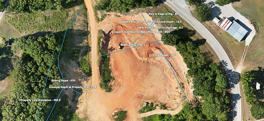
Our aerial data supports as‑built documentation throughout the life of the project. With consistent flights and standardized capture locations, you’ll have a reliable record of what was built, when, and where. This is useful for closeout packages, future maintenance, and resolving potential disputes.

Stockpile Volumes, Cut/Fill & Earthwork Reporting
Track materials and earthwork more accurately with drone‑based:
-
Stockpile volume reports
-
Cut and fill analysis
-
Earthwork progress tracking
We help you verify quantities, check against contractor reports, and reduce material overages or shortages. This is particularly helpful for road, bridge, and large site development projects across your operating region.

Scheduled Weekly (or Custom) Site Visits
We can fly your site on a weekly, bi‑weekly, or custom schedule based on your construction milestones. Each visit follows a consistent flight plan so that imagery, models, and measurements can be directly compared from one visit to the next.

How Our Construction Progress Monitoring
Process Works
-
Initial Consultation
We discuss your project type, location, schedule, safety requirements, and what you need to document (buildings, roads, structures, utilities, stockpiles, etc.). -
Flight Planning & Coordination
We review airspace, site access, and any special constraints. Our team coordinates with your superintendent and safety personnel to align with your site rules and schedule. -
On‑Site Drone Operations
Our FAA‑certified remote pilot conducts each flight following your safety protocols and all applicable regulations. We work around your crews and equipment to minimize disruption. -
Data Processing & Analysis
Imagery is processed into usable deliverables such as photos, videos, orthomosaics, 3D models, stockpile reports, and cut/fill maps. -
Delivery & Review
You receive secure links to download your files or view them online. We can walk you through the deliverables so your team understands how to use them for reporting and decision‑making. -
Ongoing Monitoring
For recurring projects, we maintain a consistent schedule and capture plan so each new dataset can be compared directly to previous visits for true progress monitoring.

Safety, Compliance, and Professionalism
-
Aerial Ops Drone Services operates with safety and compliance as top priorities:
-
FAA Part 107 certified remote pilot
-
Operations in compliance with all applicable aviation regulations
-
Insurance coverage appropriate for commercial construction and infrastructure sites
-
Adherence to your site safety plans, PPE requirements, and orientation procedures
-
Coordination with your team to avoid interference with cranes, equipment, and critical path activities
-
You get professional‑grade data without compromising jobsite safety.

Service Area
-
We are based in Springfield, Missouri and provide construction progress monitoring drone services across a broad regional footprint, including:
-
Southwest Missouri
-
Northern Arkansas
-
Central and Eastern Oklahoma
-
Eastern Kansas
-
If your project is located within this region—or nearby—reach out and we’ll confirm coverage and mobilization options for your site.

Who We Serve
-
Our services are tailored for:
-
Commercial general contractors
-
Mid to large‑scale builders and developers
-
Infrastructure contractors working on:
-
Roads and highways
-
Bridges and overpasses
-
Utilities and rights‑of‑way
-
Large site development and industrial projects

Frequently Asked Questions
1. How often can you monitor our construction site?
Most clients choose weekly or bi‑weekly flights, but we can customize the schedule based on your milestones, inspection needs, or owner reporting requirements.
2. What do we need to do before each drone visit?
We ask that you confirm site access, identify any restricted areas, and share updated safety requirements. Our pilot will coordinate with your superintendent or site contact before each flight.
3. Can you work within our existing safety plan?
Yes. We follow your site‑specific safety rules, attend orientation as required, and coordinate with your safety and operations teams so that flights are integrated smoothly into your jobsite routine.
4. How quickly do we receive deliverables?
Turnaround times depend on the scope of the visit and deliverables required, but standard photo and video documentation is typically delivered within 24–48 hours. Orthomosaics, 3D models, and volume reports may take slightly longer.
5. Can you compare progress over time?
Yes. We fly repeatable missions from the same heights and angles so that imagery, maps, and models can be directly compared week to week or month to month. This is ideal for true progress monitoring and as‑built documentation.

Request a Construction Progress Monitoring Quote
Get reliable, professional construction progress monitoring for your next project.
Use the form below or call us to discuss your site, schedule, and documentation needs. We’ll recommend a monitoring plan and provide a quote tailored to your project.
