
Portfolio
Our Portfolio
Aerial Ops is proud to showcase successful projects that highlight our commitment to precision, safety, and innovation. From construction sites to infrastructure inspections, our work speaks for itself.
Featured Projects

Quarry Mapping for Resource Optimization
Challenge: Improve material tracking and reduce waste.
In a large quarry operation, accurately tracking the volume of stockpiled materials is crucial to optimizing resource use and reducing waste. Traditional manual measurement methods were slow and prone to errors, leading to inefficiencies and higher operational costs.
Solution: We used drone-based aerial imagery to create detailed 3D models and volumetric maps of the quarry site. These models allowed for precise calculation of material quantities and better management of resources. By overlaying these maps with real-time data, the project team was able to optimize material stockpiles, adjust excavation plans, and plan resource allocation more efficiently
Result: By leveraging accurate 3D mapping and volumetric analysis, the team reduced waste, improved site management, and saved $25,000 in operational costs.
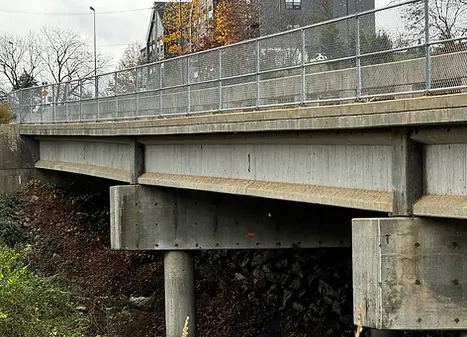
Bridge Safety Inspections
Challenge: Inspect aging infrastructure without disrupting traffic.
With aging bridges requiring frequent inspections, traditional methods often demanded costly and time-consuming road closures. This disrupted traffic flow and added delays, making it difficult to conduct timely and thorough assessments of bridge conditions.
Solution: Using drones equipped with high-resolution cameras, we performed detailed aerial inspections of the bridges. These drones captured clear, close-up images of structural components, including hard-to-reach areas like beams and understructures. The aerial footage was processed into inspection maps that highlighted areas needing attention, such as cracks or corrosion.
Result: The drone-based inspection process drastically reduced the time required for the inspections, cutting inspection times by 40%. The technology ensured compliance with safety standards while minimizing disruption to traffic. It also saved on labor costs and eliminated the need for road closures, resulting in a safer and more efficient process.

Precision Mapping
Challenge: Achieve accurate site mapping for better planning and resource management.
Construction projects often require detailed mapping to ensure precise planning, effective resource management, and risk mitigation. Traditional survey methods can be costly, time-consuming, and prone to errors, especially when large, complex sites are involved.
Solution: We used drone technology to create highly detailed 2D orthophotos and 3D models of the construction site. These maps provided an accurate, scalable representation of the site, capturing topographical features and terrain variations that are crucial for effective project planning. The 3D models allowed for accurate volumetric analysis, helping teams to assess material quantities and adjust plans accordingly.
Result: With precise mapping, the project team gained valuable insights into site conditions, enabling them to plan more effectively, allocate resources efficiently, and avoid costly mistakes. This resulted in better project outcomes and smoother project execution.

Construction Site Progress Monitoring
Challenge: Regularly monitor and report construction progress to stakeholders.
Tracking construction progress is essential for staying on schedule and ensuring that milestones are met. Traditional methods of progress reporting can be slow and inefficient, leading to communication gaps and delays in decision-making.
Solution: We provided regular aerial imagery and updates to monitor construction progress. By creating 3D models and using 2D orthophotos, we gave stakeholders real-time access to site updates, allowing them to visually compare progress to the planned timeline. This data helped the team spot potential delays or issues early, facilitating quick adjustments.
Result: With ongoing, real-time aerial updates, stakeholders were able to stay informed, make data-driven decisions, and maintain a proactive approach to site management. This led to fewer delays, improved communication, and smoother project execution.
Other Projects


